Browse Primary Sources
Locate primary sources, including images, objects, media, and texts. Annotations by scholars contextualize sources.
Seneca the Younger, Moral Letters to Lucilius
Moral Letters to Lucilias was written by the Roman philosopher Seneca the Younger around 65 CE. There are 124 letters in the collection.
Sophocles, Oedipus the King
Oedipus the King, also known as Oedipus Rex, is an ancient greek play written by the Athenian philosopher, Sophocles, around 420 BCE. The text presented is an excerpted portion from the second half of the play.
Homer’s The Iliad
Homer's The Iliad is an ancient greek poem written around the eighth century. The poem is set during the Trojan war and highlights the conflict between King Agamemnon and the warrior Achilles. The text provided is an excerpt from book three.

Map of the Partition of Israel and Palestine
In 1947, Britain announced that it would terminate its mandate government in Palestine. As a result, a special committee formed by the United Nations was charged with partitioning the territory into separate, sovereign states. Although the plan called for Jewish and Arab states neatly divided by plotted lines, the reality, as these maps show, was much more contested.
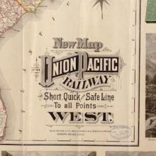
Map of the Union Pacific Railway
This 19th century map illustrating the many places one could travel on the Union Pacific Railway is the product of a multitude of choices made by the mapmaker. As a product for, and advertisement of, the Union Pacific Railroad, it obviously only depicts that one railway to the neglect of all of the others that were beginning to be built in the late 19th century.

The Gall-Peters Projection
Unsatisfied by the distorted view of the world that dominated the Western mind in the form of the Mercator Projection, James Gall and, later, Arno Peters engineered a new map in the 19th and 20th centuries. Based on a mathematical formula that Gall first proposed in the 19th century, Peters projected an image of the world that attempted to capture the size of objects relative to each other.

The Mercator Projection
Although the Flemish geographer and cartographer Gerardus Mercator's rendering of the earth has been criticized for the way it distorts reality, it was revolutionary in the way it organized space and distance.

The Jingban tianwen quantu Map of the World
Like many maps in the pre-modern and early-modern world, this map from China at the end of the 18th century reflected a deeply egocentric worldview.

Babylonian Map Tablet
This ancient map depicts the known world as imagined by the Babylonians of the 6th century BCE. Like many ancient maps, this cuneiform tablet is concerned less with mathematically plotting space and direction than with simply capturing the various places and peoples in the world around Babylon.

The Turin Beatus Map of the World
Before the modern age, maps offered more than just an objective, geographical survey. Often, as is the case with this world map from the 12th century, they also conveyed a set of stories that shaped the worldview of its viewers. This map, for instance, sought to convey allegorical, religious, and geographic information all at once.

Marshall Islands Stick Charts
The Marshall Island stick charts represent a unique and non-Western tradition of mapmaking. Whereas Western maps generally attempt to capture and visualize distance and space, the charts of the Marshallese dwelt not just on general direction, with shells representing nearby islands, but, more importantly, ocean currents and swell movements.

Plan for the City of Moscow
This 1793 map of Moscow shows a relatively modest and compact city when compared to the sprawling metropolis of the 21st century. From this perspective, the viewer can see the remains of a fortification wall that once encompassed the entirety of the city.

Map of Poverty in Mexico
Maps are often designed to visualize more than just space and distance. This map, for instance, visualizes how poverty is distributed throughout the various Mexican states in hopes of identifying those areas most in need. The form of this map, or the artistic way in which the map is drawn, is meant to tell the story of how deeply the issue of poverty affects the people in each region.

Ptolemy's World Map
Ptolemy was an ancient geographer working in Rome in the 2nd century AD.

Africae tabula noua
This standard map of Africa came from a popular Atlas in the late sixteenth century. In a dramatic age of exploration, new information poured in from around the world through books and travel accounts that artists and geographers, like Abraham Ortelius, used to craft beautifully detailed maps of far off lands.
Excerpt from Aguinaldo’s Case Against The United States
The Philippines, an archipelago of over 7,000 islands in the western Pacific Ocean, had been a Spanish colony for over 300 years by the 1890s. Filipino nationalists led by Emilio Aguinaldo rebelled against Spanish rule beginning in 1896. When the United States declared war against Spain over events in Cuba in 1898, the U.S. Navy moved against Spanish colonies in the Pacific as well. U.S.

Buddha Sheltered by a Naga
This small bronze statue made in Cambodia in the twelfth century shows the serpent king Muchilinda, a type of mythical half human and half cobra being known as a naga, protecting the Buddha. Images of this scene became popular in the twelfth century Khmer Kingdom of today’s Cambodia, sponsored by King Jayavarman VII (c. 1122–1218), a strong supporter of Buddhism.
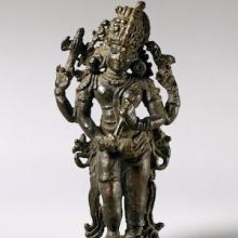
The Half-Male, Half-Female Form of Shiva (Shiva Ardhanarishvara)
This sculpture is of Shiva, originally found in Kerala, southwestern India, shows the importance of religious symbols in Hinduism. Shiva is a major Hindu god who is associated with the opposing ideas of destruction and regeneration.

Kilwa Map Illustration
This illustration shows the trading city state of Kilwa or Kilwa Kiswani on an island off the Swahili Coast in East Africa (modern Tanzania), which flourished between the 12th and 15th century.

Navigational Charts Based on Those Used by Zheng He
These two woodblock prints are part of a map printed in a seventeenth-century military treatise, and thought to be based on the maps used by Zheng He in his voyages. The map is therefore usually known as “Zheng He Map.” It depicts the coastline from China to the central eastern coast of Africa arranged as a long strip.